

Arches National Park is on the homeland of the Ute Nation (Núu-agha-tʉvʉ-pʉ̱ or Nuutsui) who have used and lived on the land since time immemorial. The land that now makes up the park was ceded in the treaty of 1868 largely through negotiation between Kit Carson and Chief Ouray. Unlike some treaties from that era where tribes retained certain rights over ceded land, the “Kit Carson” treaty specifically stipulated that the Ute relinquish all claims and rights over the land - reflective of the treaties main purpose to open up for mining and settlement. Various Ute communities were removed to a large unified Ute reservation in Colorado where they were often forced to remain sometimes through military action.
But Arches is and has been a spiritually, culturally, and economically important site for more nations that just the Ute including the Zuni (A:shiwi), Hopi, Paiute, and Navajo. None of these nations signed treaties ceding their ancestral rights over the land and yet the Ute treaty meant they also were barred from access to what would become Arches. Giving hard borders to different nations was an intentional strategy of removal by the United States to dispossess as many Indigenous people as possible for the least amount of money and effort. While treaties were made with individual nations, in practice, the U.S. considered the land cessions of any treaty to apply to all “Indians,” if not the payments. When visiting Arches, it is important to remember that while the land may have been legally ceded by the Ute (although we know many treaties were forced), it is and remains unceded, illegally occupied land for many more nations
Great Bay National Wildlife Refuge is Peskategwa Land

Great Bay National Wildlife Refuge is on the homelands of the Peskategwa People. The Peskategwa (or Piscataqua) were Abenaki and members of the Pennacook Confederacy, which developed under the leader Passaconaway in response to colonial expansion into what is now New Hampshire and Maine. The community was devastated by the 1620 smallpox pandemic and then by Kind Philips War, despite being neutral. The confederacy officially came under British sovereignty in the Treaty of Portsmouth in 1713, but the land had likely already been sold by Passaconaway in one of the many less formal Indian Deed sales.
When we talk about defined communities of people that are no longer around, it is important to remember that there are still descendants of the Pennacook today. The merging and renaming of communities and nations was common as tribes in the east tried to consolidate after the devastating impacts of colonialism. The insistence by some historians that a tribe is “extinct” is part of the colonial project, designed to legitimatize settler ownership of the land and invalidate any rights and sovereignty the Indigenous communities had retained in treaties and sales. For example, some original deeds from the area protect the right of tribes to farm, hunt, and gather on sold land - a right that disappears if the tribe is dissolved. Today, the unrecognized Cowasuck Band of the Pennacook-Abenaki People represent the contemporary Indigenous communities of the area.
Mount Rushmore is Lakota Land
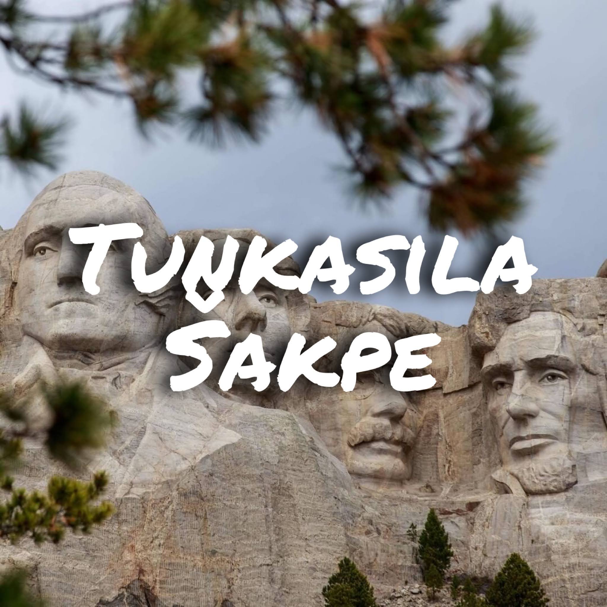
(Tȟuŋkášila Šákpe or the Six Grandfathers in He Sapa “The Black Hills) Tȟuŋkášila Šákpe is on Lakota Land, land that even according the the laws of the United States was unconstitutionally taken (see United States vs. Sioux Nation of Indians 1980). I am going to save the history of He Sapa for another day because it deserves its own post. Instead I want to look (very briefly) at the history the faces carved on the mountainside and why, beyond the desecration of the land, the choice of these four faces to represent America is especially insulting. This is not exhaustive, so use this as a basis to learn more.
Washington: Known as Conotocaurius “The Village Destroyer” by the Seneca both because of his family history and his own involvement in the total destruction of some 40 Iroquois villages during the Revolutionary War. The war itself was partially because Washington (and others) had land investments west of the Appalachians that were valueless until the Indigenous people could be removed - something the British refused to do.
Jefferson: The Louisiana Purchase annexed land to the United States before any negotiations with local tribes occurred, helping set the standard for Indigenous people as illegitimate nations in the eyes of the U.S. Not to mention that the section on “Merciless Indian Savages” in the Declaration of Independence were his words.
Lincoln: Approved the largest mass hanging in U.S. history of 38 (+2) Dakota prisoners of war. He also signed the legislation that gave legal framework to the largest transfer of wealth in U.S. history from Indigenous people to mostly white, immigrant families and large railroad corporations through the Homestead Act and Pacific Railroad Acts.
Roosevelt: This 1886 quote, “I don't go so far as to think that the only good Indian is the dead Indian, but I believe nine out of every ten are, and I shouldn't like to inquire too closely into the case of the tenth,” plus his enthusiastic support of the Dawes Act (look up Allotment), his early advocacy for what would become Termination Policy, and of course further dispossession through the National Parks - the focus of this account.
These four presidents were chosen for Mount Rushmore because they represented the progression and growth the U.S. - a deeply colonial process that necessitated violence toward Indigenous people. The two cannot be separated. The question of whether the monument should be removed or destroyed is irrelevant until the land it is on is repatriated to the Lakota. They can then make that decision themselves.
Goblin Valley State Park is Ute Land

I recently visited Goblin Valley State Park on traditional Ute homeland. This is a beautiful space, but I was totally appalled by two things that are unfortunately too common on public land in the U.S. - the complete erasure of the Ute from the interpretation and the rampant vandalism and I think these two things are connected. Signs around the park suggest the area was a desert wasteland until settlers first found it and the website’s first line is literally “Cowboys searching for cattle first discovered secluded Goblin Valley.” This is despite the park being home to what interpretations calls “archaic artifacts.” This type of interpretation is designed to create a claim of ownership by settlers over a space. It is “our” land as Americans, right? We can do what we want with it, right? It is this sense of ownership by settler tourists that entitles them to play tic tac toe or draw pseudo petroglyphs on the rocks.
If we want to really address vandalism and misuse of outdoor spaces, the solution isn’t to stop geotagging or restrict access, it is to radically shift tourists understanding of the history and culture of these places and realign their relationship to them. This begins with interpretation and telling the real, difficult history of public lands, but it is really only finished with repatriation and indigenous management of public lands. Tourists aren’t owners, they are guests.
Princeton University is Ramapough Lenape Land
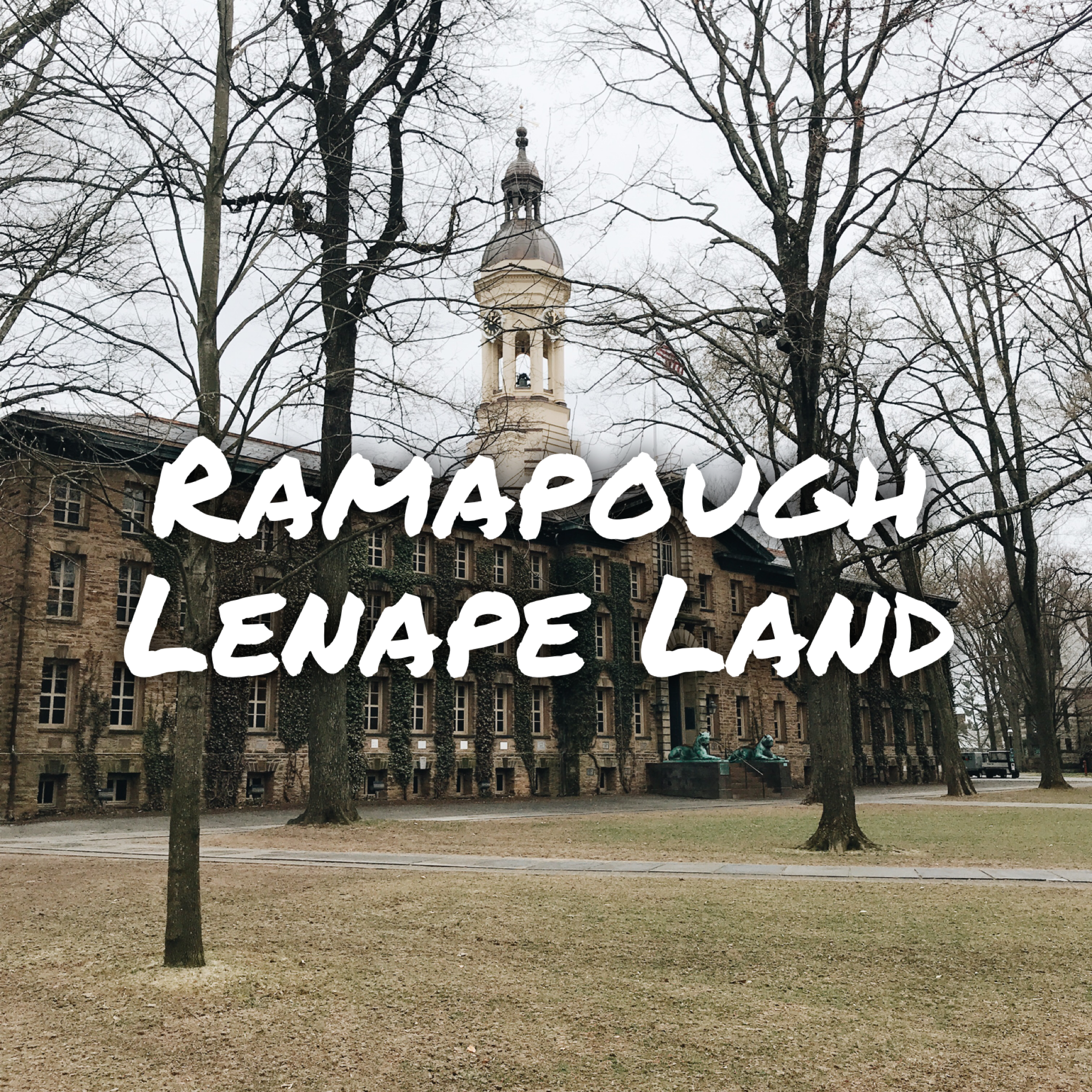
Princeton University is the homeland of a number of Lenape bands now represented by the New Jersey state recognized Ramapough Lenape nation. I am here at an indigenous studies conference that has been put together by a group of really dedicated grad students, but it is clear that in general, addressing the history of Lenape dispossession and what it should mean for a contemporary university is not something Princeton does very often. And it’s not something most universities talk about very much. If you are involved in a university (or high school or any school) as a student, faculty, staff, alumni, or whatever, make sure your school is addressing this issue. Are they making sure every student know whose land they are on? Are they building relationships with local tribal nations or urban indigenous communities (your city has one even if you don’t know about it)? Are they recruiting local Native students, making sure they are supported financially and administratively? I know university system are not designed to be transparent and easily navigated, but let’s at least start this conversation.
The Virgin Islands National Park is Kalinago and Taino Land

The island of St. John’s in the Virgin Islands National Park is the homeland of the Kalinago (Island Carib) and Taino people. These two nations were the first to encounter the impacts of European colonization in the Americas. The history of these people is different than many American Indians in the mainland United States in that they weren’t displaced and do not fall under contemporary Indian law that structure the relationship between the U.S. and most other indigenous people on land it occupies. Instead, the Kalinago, who lived on the islands at the time of Columbus, were almost immediately enslaved.
The islands subsequently were occupied by France, Denmark, Britain, and finally the United States. With the notable exception of some Kalinago communities who managed to isolate themselves from colonizing forces, like the current self-governing Kalinago territory on Dominica, most Kalinago people intermarried with European settlers and African slaves, a cultural fusion that has created the distinctive Afro-Caribbean culture of the islands.
While this culture is important, is also has been used to erase the indigeneity of people of Kalinago descent in the Virgin Islands in a legal sense if not in the eyes of the people themselves.
And this is how settler colonialism works. Since indigeneity is a threat to the right of colonizers to occupy space, the system is designed so that all other identities subsume Indigenous identities. Black, white, Latin American, Afro-Caribbean, anything but Indigenous.
When you visit the Virgin Islands, remember that this is Native land and that complex, intersecting identities and backgrounds, while complicated and sometimes contradictory, don’t erase the resilience of Indigeneity in these spaces.
The Arctic National Wildlife Refuge is Inupiat Land ... but also more that.

Arctic National Wildlife Refuge (ANWR) 📸 @isaccoemiliani - ANWR has made its way back in the news as oil and gas exploration is moving forward in the area. This is a complicated issue, but I want to give some very abbreviated background here for you all. When we talk about drilling in ANWR, we are talking about the 1002 area on the north slope. This is traditional Inupiat Land and falls within the Arctic Slope Regional Corporation (ASRC), one of the 13 Native corporations held by Alaska’s indigenous people in exchange for their aboriginal claims to the land as a settlement under the Alaska Native Claims Settlement Act of 1971. As shareholders of ASRC, the Inupiat rely on gas and oil leasing for their livelihood and many, although definitely not all, support oil and gas in ANWR for this reason. The Gwich’in people live to the south and are shareholders in Doyon Ltd., a Native corporation that will see little of the profits coming out of ANWR. However, many Gwich’in communities rely on the Porcupine Caribou herd which migrates through area 1002 of ANWR and fear that the herd and their livelihoods may be impacted by extraction. Many Gwich’in people, but not all, oppose gas and oil exploration in ANWR for this reason. Many people in both communities oppose it because of a myriad of environmental reasons and the fear that the interests of the Native corporations are not taking into account the concerns of local communities.
What I’m trying to say is that for local Native communities, this is a complicated issue on many levels. However, one way it is not complicated is the way is shows the meaninglessness of the Wildlife Refuge status. Bears Ears with its removed and then restored National Monument status is another example of this. Conservation based land designations are only valid until state or corporate interests decide they are needed for any other reason - usually economic development or defense. ANWR shows once again that we cannot rely on the government for permanent protection of the environment.
Paterson Great Falls National Park is Acquackanonk Lenape Land

Paterson Great Falls National Park in what is now New Jersey is on the homelands of the Acquackanonk tribe of Lenape (Delaware) people. The Lenape called the area Totowa, meaning to be forced under water, or sometimes just Sokpehellak or Sookpehelleu, meaning waterfall. When the Dutch settled in the area beginning in 1624, they brought with them drastic economic and environmental changes. The Lenape has tense relations with the Dutch to say the least including the infamous “Slaughter of the Innocents” at nearby Pavonia where 120 Lenape people were massacred. After a series of retroactive purchases, legalizing earlier Dutch and Anglo settlement on Lenape land, the tribe eventually singed the Treaty of Easton in 1758 forcing the remaining Lenape to move to Ohio - this history is long and complicated and beyond the scope of an Instagram post. Today the Lenape consist of three federally recognized tribes in Oklahoma and Wisconsin.
Paterson Great Falls National Park, along with most histories of the falls I could find, covered the entire history of the Lenape in the area in a single sentence which ended with the settlement of the Dutch. I don’t want to say the history they do cover about Immigration and the Industrial Revolution is unimportant, but all of it rests on unacknowledged injustices, a story that should change how we view all subsequent events. This type of history is extremely common in the parks and gives the impression that Native people passively disappeared at the appearance of Europeans rather than the fact that people like the Lenape are contemporary political nations still surviving even after 250 years in exile from their homelands. Make sure to learn all the history.
San Diego is Kumeyaay Land

[Sunset Cliffs Natural Park] Sunset Cliffs and much of the city of San Diego is the homeland of the Kumeyaay people. While today they retain just a fraction of their original land across 17 small reservations in California and Baja, Mexico, for thousands of years, nearly the entire California/Baja borderlands were Kumeyaay lands - lands they lost through multiple waves of colonization in the area. They were among the first to experience the violence of the Spanish mission system and lost even those mission land claims when Mexico secularized the system after independence.
Under American occupation, white settlers continued to encroach on what they considered “newly opened” land and while Kumeyaay land claims were finally acknowledged 1875 in the form of 13 inland reservations on the American side, sacred spaces, burial sites, and land important for maintaining traditional economies - especially coastal land - were excluded. However, while land was lost, the Kumeyaay people continue to live throughout their traditional homeland and maintain multiple sovereign, nation-to-nation relationships with the U.S through their federally recognized tribes. I talk a lot about public lands and outdoor spaces here, but remember every city, every beach, every local park exists on Native land. San Diego is Kumeyaay Land.
Saguaro National Park is Tohono O'odham Land

{Saguaro National Park image originally posted by @nationalparkservice} Saguaro National Park is on Tohono O’odham homeland. Because of how close the current Tohono O’odham Nation is to the park, it seems like NPS does a pretty good job of working with the tribe on management issues, especially around harvesting Saguaro fruit. Nevertheless, it is important to remember that this is still stolen land, still land that carries with it a violent history of mission system labor, and still land managed for purposes not always aligned with those of the Indigenous people.
Public Land is Stolen Land

{Shenandoah National Park originally posted by @usinterior - Traditional Monacan homeland} Happy #NationalPublicLandsDay! I wanted to take this moment to talk about why we use the words “stolen” and “theft” when we talk about the acquisition of Indian land on this account. The idea that Indian lands - the lands out of which America's #publiclands were carved - were won through Right of Conquest, not making it theft, is an argument I hear a lot.
This is a misconception.
First of all, Right of Conquest, the idea that territory won in war belongs to the victor, is deeply unethical. I think most people agree that just because you have the power to take something, doesn't give you the right to it. However, even if you accept Right of Conquest, that isn't how Native land was taken by the United States. Land was acquired through Treaties between the U.S. and sovereign Indigenous nations, not through war.
Legal from a technical standpoint, these treaties were often coercive, misleading, or forced upon tribes. Translators and negotiators would often lie, cheat, intimidate, and even forge marks to get these treaties. On top of this, the U.S. failed to hold up their side of the treaties - letting settlers on land reserved for the tribes or not providing payment promised - effectively voiding the treaties.
Public Lands are part of this history of broken treaties. Many public lands have restrictions that result in tribes being unable to practice their treaty rights or encroaching on resource sovereignty. Military campaigns against tribes were mostly used to undercut treaties, to force tribes into signing treaties, or to "pacify" tribes who had returned to their lands after treaties were broken. The military was used in conjunction with outright lying, cheating, and intimidation by political representatives of the U.S. to Indian nations to underhandedly acquire land. This - even in its own time - is land acquisition through theft, not through conquest.
Language and history are important. When Native people say "theft" they actually mean theft. The way these lands were illegally taken has political consequences today, so let's be accurate.
Curecanti National Recreation Area is Ute Land

{Curecanti National Recreation Area image posted by @usinterior} Curecanti NRA is a series of reservoirs on the Tomichi (Gunnison) River on traditional Ute homeland. The Ute Nation had used and lived on this land for hundreds of years, but were forced off in the late 19th century to make way for mining and ranching by white settlers. The two groups represented a clash in land use. As the Denver Tribune put it, “Either they [the Utes] or we must go, and we are not going. Humanitarianism is an idea, Western Empire is an inexorable fact.” So settlers were pretty explicit about putting empire ahead of the lives of people. The river was dammed in the 1960’s flooding many important cultural and archeological sites including petroglyphs, and is now used for boating and water recreation.
The damming of Tomichi brings up a justification that is repeated on many public lands - the idea that this land was only “seasonally” used or used only for hunting and gathering and therefore Native people have fewer rights over it than if it were permanently lived on. I’ve talked about this before in regards to historical interpretation, but this viewpoint values permanence and settlement over other life ways. When white settlers came to Colorado, they argued that the Ute did not properly use the land and therefore had no right to it - only land uses legible to Euro-Americans were considered proper. Just because you don’t understand the land use does not mean it isn’t used. Just because it is now under water, does not mean it isn’t still important to Ute people.
Lake Tahoe is Wašiw (Washoe) Land

{Lake Tahoe posted by laketahoeofficial} Da ow (Lake Tahoe) and the surrounding area falls within Dit eh hu’, the homeland of the Washoe (Wašiw) people. The Washoe had been in Dit eh hu’ since time immemorial and managed to avoid most Euro-American incursion until the California gold rush of 1849. Huge numbers of white settlers drastically disrupted the ecosystem and Washoe way of life, destroying the piñon forests and causing collapse in the Tahoe fish populations forcing the Washoe to adapt to the American economy.
Today the Washoe are members of the Washoe Tribe of Nevada and California, the Reno-Sparks Indian Colony, and the Susanville Rancheria. Despite Tahoe being derived from the Washo name Da ow, the Washoe still are still fighting to be included in decisions made about the land as well as reclaim stolen land in the area including a current push to have 375 acres of federal land in Incline Village transferred to the tribe instead of privatized or transferred to the state.
Denver is Arapaho, Cheyenne, and Ute Land

Denver is on the homelands of the Arapaho, Cheyenne, and Ute people (niineniiniicie is the Arapaho name for Denver), but also has a very diverse Native population due to being a relocation city - where the government provided incentives for American Indians living on reservations to move to urban areas in the 1950’s.
Since the outdoor industry relies so heavily on public lands, lands often acquired illegally from or through violence against indigenous people, it is good to see more effort to include Native voices in this summer’s retailer including a Tribal Summit organized by @nativeoutdoors and @patagonia. However, this is just a beginning. I want to encourage the outdoors people who follow this account, especially the non-Native outdoors people, to continue to learn about the histories of the lands they hike and camp on and continue to push for greater acknowledgement of and collaboration with Native nations by the companies they buy from and work for. You guys have power. Use it.
Ozark National Scenic Riverways is Osage and Quapaw Land

{Ozark National Scenic Riverways image originally posted by @usinterior} The homeland of the Osage and Quapaw Nations, Ozark National Scenic Riverway is a great example of the bias settler history and interpretation puts on the built environment. As the National Park service itself says, this is a place with a long and rich human history where “every time and every group of people has a story to tell.”
However, the stories they tell are largely tied to structures in the park, built environments legible to American society. This tendency to tell the stories of buildings, and this is true throughout the country, erases indigenous impacts on the environment that were often more ephemeral or simply unrecognizable as human intervention to European settlers - thus also erasing indigenous history and presence from the land. (Let’s also not forget that archeologists and explorers often ascribed the permanent structures that were built by Native people to mythical or lost races because they refused to believe American Indians could build them). How much someone leaves behind should not be the basis for whose stories get told.
Denali National Park is Dena'ina, Tanana, Koyukon, Ahtna, and Upper Kuskokwiim Land

{Denali National Park image originally posted by @usinterior} The homeland of the Dena’ina, Tanana, Koyukon, Ahtna, and Upper Kuskokwim, Denali National Park and Reserve does a better job than most public lands at acknowledging the cultural history of its constructed wilderness including officially restoring the name of the mountain. This is important because instead of centering recreation as the first and most important human use of the park, it places it in the context of a 12,000+ year human history of the area.
However, it still fails to address the role of colonialism in the park. Unlike in the mainland U.S., aboriginal land claims in Alaska were eliminated in the Alaska Native Claims Settlement Act of 1971, creating Native corporations rather than sovereign nations. Because of this, while Denali allows subsistence and traditional uses (hunting, gathering, fishing, etc.) in the park, it doesn’t differentiate between Indigenous traditional use and settler traditional use - and would have no legal basis to do so under Alaskan law. Many settler families of course rely on the subsistence economy, but the conflation of the two histories obscures the different pasts and power dynamics of these groups, suggesting reconciliation where conflict still exists. These histories take longer to tell and are complicated, but that doesn’t mean we shouldn’t take the time to learn them.
Monument Valley is Navajo Land

{Monument Valley Navajo Tribal National Park originally posted by @visitutah} Tsé Bii’ Ndzisgaii, what is known in English as Monument Valley, is not, contrary to popular belief, public land at all. It is sovereign Navajo (Diné) land on the Navajo Reservation.
I have seen Tsé Bii’ Ndzisgaii tagged as a national park, a state park, and a movie set and Utah sure does its best to claim it as for its own when it comes to tourism. Mislabeling a place or representing it as non-Native land isn’t the same as actually physically taking the land and removing the people that live there of course, but it is still an integral part of colonialism. Tsé Bii’ Ndzisgaii is part of a sovereign nation. When you visit respect the laws and rules of the Navajo Nations and make it clear to your followers through geotags and captions that this is Tsé Bii’ Ndzisgaii and it is on #nativeland.
Voyageurs National Park is Ojibwe Land

{Voyageurs National Park originally posted by US Interior} Voyageurs National Park on the border of Minnesota and Ontario is Ojibwe land, and Cree and Assiniboine before them. Although there was some mining in this area - and the original treaties were designed to acquire land for mining - the Ojibwe were largely pushed out of these waters by the tourism industry and 20th-century conservation. Today there are many Ojibwe reservations and reserves on both sides of the border around Voyageurs and the Boundary Waters.
Because the area is now mostly used by tourists, tourism and recreation are often seen as the only legitimate uses of this space. Therefore, despite the Ojibwe living throughout the area and retaining treaty-guaranteed resource sovereignty over the land, they can only enter their homeland as tourists and are still fighting for their rights to use the land as they wish instead of only under the same restrictions placed on non-Ojibwe visitors.
The Washington Mall is Nacotchtank Land
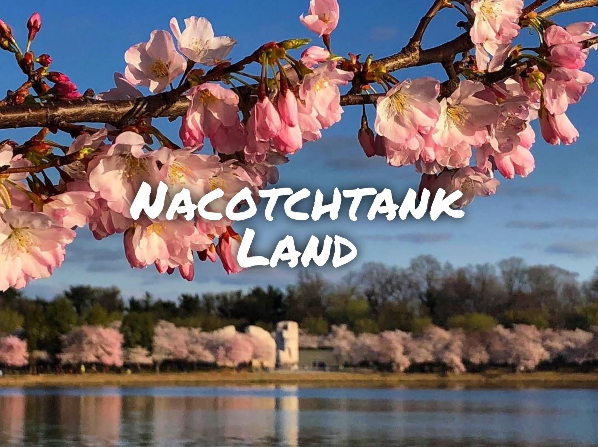
{Washington Mall originally posted by the National Park Service} The National Mall in what is now Washington D.C. was originally the village of Nacotchtank. When we talk about public land, we often thing large western parks, but the National Parks run many urban parks as well. It is important to remember that these urban spaces, especially cities like D.C. which are steeped in the American mythos, are also Native Land with complex social histories far predating European settlement.
The Nacotchtank or Anacostans controlled an important trading center bringing together a number of coastal tribes and confederacies. War and diseases brought by Europeans destroyed their network, however, forcing the Nacotchtank to disperse, joining other tribes in the region including the Piscataway, a state recognized tribe in Maryland.
Eagletail Mountains Wilderness is Yavapai Land
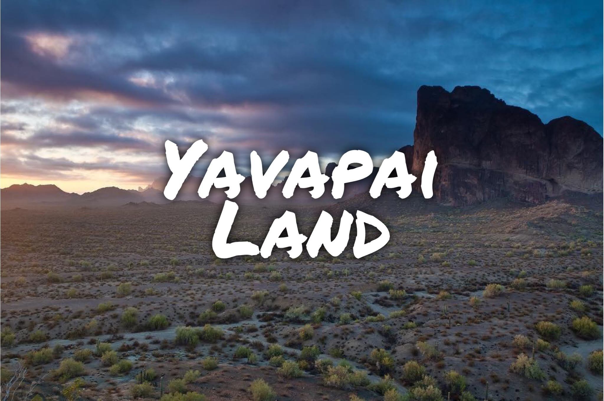
{Eagletail Mountains Wilderness originally posted by the BLM @mypubliclands} Eagletail Wilderness is on traditional Yavapai Land. The Yavapai had lived in the area between the Colorado and Gila Rivers in what is now southern Arizona for hundreds of years before European contact and Indigenous people had lived in the area for thousands of years. The Yavapai were known for their fierce resistance to the illegal white settlement on their land, eventually resulting in a forced march from their homelands to the San Carlos Reservation hundreds of miles away. Today, the Yavapai retain three reservations near or on their homeland around Prescott and Phoenix, AZ.
I’ve talked about wilderness areas before, but it’s worth revisiting. Eagletail Wilderness in no way acknowledges the Yavapai history - it cannot acknowledge recent human history and still maintain the fiction of a wilderness. Wilderness is constructed, in this case through a physical forced march of people from the region, resulting in hundreds of deaths. This land is not untrammeled, but rich in history and culture. Accepting it as wilderness is to accept the continued erasure of Indigenous people and the continued colonial policies of the United States.